| >US/AZ
Government
>World History
>Nogales
High School Web Page
Class
stuff...
>A
letter to my students
>Course
Guide in PDF
>Photos
of Old Nogales
>Socartic
Seminar Grading
>The
Habits of Mind, Heart and Effectiveness
>Position Papers
Constitution
Info
>The Founders'
Constitution
>The Federalist
Papers
>Constitution Basics
>The Constitution Society
>Arizona Legislature
>Alexis de Tocqueville, Democracy in America
|
World History and Geography
Class Organization and Basics of Georgraphy
Strand 2 Concepts 1and 2

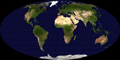
The equal-area Mollweide projection
|
|
| 8.6 |
I. Class organization
- Intros, seating, names
- Daily procedure
- Class web page
In class teachweb.org quick write review - 20 points
As the teacher shows the class the page, write what you see, and if you think it's interesting, with a reason.
- Nicenet
How to sign up for nicenet.org
Sign-up for nice net by 8/14 for 50 points
- Course Guide/Outline, and Policies
|
8.7
and 8/11 |
|
| 8.8 |
"How the earth ..."
Write: 1. What you see, 2. what you think, 3. connect to real life |
| 8.12 |
- Read and discuss (In class pgs 1 to 15)
|
| 8.13 |
|
| 8.14 and 8.15 |
Video --"How the Earth..."
|
| 8.18 |
|
| 8.19 |
|
8.20 |
- HOMEWORK ALERT !
- Email Journal to Nicenet with an answer to these questions in a few sentences.
- What do you expect from this class?
- What do you think is meant that "Geography is destiny? Due 8.21
- Review the Five Themes of Geography
- Quick write - in class - Pick one idea from the theme and relate/connect it to your life.
|
| 8.21 |
|
| 8.22 |
|
| 8.25, 26, 27 |
Use the newspaper, magazines, pamphlet, flyers, etc. (whatever is the most readily available) to cut out an example of each of the five themes of geography (Use your notes to help you find examples.):
* Location
* Place
* Human Environment Interaction
Human Geography
Region
Movement
# Paste or tape the examples to a piece of paper, leave room for some writing.
# Next to each example you cut out, write what theme it represents and a sentence stating why it represents that theme.
|
The Five Themes in Geography
The Five Themes were developed by the National Council for Geographic Education to provide an organizing framework for the presentation of geographic materials.
The Five Themes are as follows:
1. Location: Position on the Earth's Surface (Absolute/Relative). Geographic study begins with the location of places on the earth. Places have absolute locations that pinpoint them on the earth, and relative locations that place each location in respect to other locations. For example, North Dakota has an absolute location that can be pointed to on any basic map. It also has a relative location in that it has a location within the economic system based on its characteristics and location within the world market. North Dakota has its absolute location's characteristics for soil and climate, yet the success of wheat growing is also related to its location to the edge of more expensive arm land to the east.
2. Place: Physical and Human Characteristics. Place have physical and human characteristics that make them what they are. Geography emphasizes the understanding of both of these factors and their integration together.
3. Human/Environment Interactions: Shaping the Landscape. The landscape of the earth is no longer a purely physical feature. Human have impact every area of the earth, but in varying ways. The geography of places is influenced by the degree to which humans have impacted their local environment.
4. Movement: Humans Interacting on the Earth. The postmodern world is one of great interaction between places. This movement is inherently geographic, whether it is by telecommunications or ship.
5. Regions: How They Form and Change. The essential geographic feature is the region. A region is any unit of space that is unified by the presence of some characteristic. The Corn Belt, stretching from Indiania to eastern Nebraska, is an area in which corn is a dominating product. The Corn Belt is a region within the United States. |
|
| 8.28 |
|
Concept 1: The World in Spatial Terms
PO 1. Construct maps using appropriate elements (i.e., date, orientation, grid, scale, title, author, index, legend, situation).
PO 2. Interpret maps and images (e.g., political, physical, relief, thematic, Geographic Information Systems [GIS], Landsat).
PO 3. Use appropriate maps and other graphic representations to analyze geographic problems and changes over time.
Concept 2: Places and Regions
PO 1. Identify the characteristics that define a region:
a. physical processes such as climate, terrain, and resources
b. human processes such as religion, political organization, economy, and demographics
Language Standards:
The student will:
• Consistently determine the meaning of content area vocabulary using an expanded range of Greek and Latin roots and affixes. (10R 1-4: PO1; 12R 1-4: PO1)
• Determine the meanings, pronunciation, syllabication, synonyms, antonyms, parts of speech, and correct spellings by using dictionaries, thesauri, glossaries, CD-Rom, and the Internet when available. (10R 1-4: PO5)
|
|


